The scientists, engineers, and technicians at Berkeley Lab’s Geosciences Measurement Facility (GMF) develop advanced instrumentation, sensor networks, and data acquisition systems in support of some of the most critical and challenging Earth and environmental observations taking place in diverse settings around the world. Complementing an extensive inventory of field research equipment, GMF delivers custom-designed instrumentation solutions to enable biological, geological, and chemical discoveries about our Earth system processes in some of the hardest-to-access places on Earth.
From within the GMF’s High-Bay, machine shop, electronics lab, fabrication lab, and borehole testing areas, our experts create and test custom instrumentation solutions in support of projects associated with subsurface, terrestrial, atmospheric, and ocean-based research. Many of these solutions enable researchers to make observations in extreme conditions about processes that span micro-scale to field-level observatories. GMF has supported the work of several R&D 100 award-winning projects from Berkeley Lab, such as the Carbon Flux Explorer and Continuous Active Source Seismic Monitoring (CASSM) system.
DEEP SOIL WARMING
Challenge: Soil organic carbon harbors three times as much carbon as Earth’s atmosphere, but until recently studies of how warming affects the amount of carbon released from soil into the atmosphere were limited to investigations of the top five to 20 centimeters of soil. The majority of field-based soil warming experiments had ignored the extent to which deeper layers of soil respond to warming–even though experts estimate soils below 20 centimeters in depth contain more than 50 percent of the planet’s stock of soil organic carbon.
Solution: The need to better understand the response of all soil depths to warming is underscored by projections that, over the next century, deeper soils will warm at roughly the same rate as surface soils and the air. Using a custom measurement system developed at GMF that includes data acquisition hardware and software systems control, Berkeley Lab scientists tested the impact of warming on deeper soil layers at a field site in the foothills of California’s Sierra Nevada mountains. The team inserted heating cables two meters underground to warm soil plots to 4 degrees Celsius, and measured CO2 concentrations at five depths between 15 and 90 centimeters using stainless steel “straws” once per month. Automated chambers measured the flux of carbon within the top 20 inches every half hour throughout the two-year duration of the experiment.
Impact: This experimental setup enabled the researchers to conclude that 40 percent of the observed increase in CO2 released at the warmed plots was due to CO2 that came from below 15 centimeters. They also found the sensitivity of soil to warming was similar across the five depths. These findings suggest the degree to which soil organic carbon influences climate change may be currently underestimated.
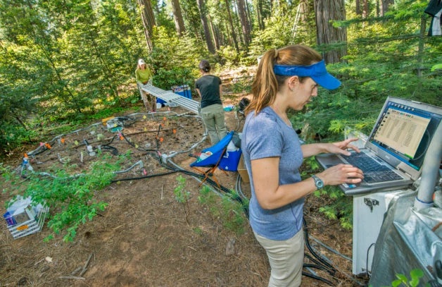
Field Site: California’s Sierra Nevada Mountains
SURFACE ORBITAL VIBRATOR AND DAS
Challenge: With the availability of Distributed Acoustic Sensing (DAS) and permanent arrays for seismic surface monitoring, the remaining limitation to achieving high temporal resolution time-lapse imaging of the subsurface is the continuous availability of a seismic power source, which can be costly to frequent deployments. One solution enabling near-continuous time-lapse imaging is the coupling of DAS with a powerful, continuous, and economic source of energy, allowing acquisition of repeat datasets with short delays and high availability to guide reservoir management decisions.
Solution: The Surface Orbital Vibrator (SOV) is an automated seismic energy source developed at the GMF to enable DAS-based continuous time-lapse monitoring. More compact than traditional seismic energy sources used in reservoir monitoring, the SOV reduces the amount of energy emitted per unit time, producing outputs that are robust, controllable, and repeatable. The SOV generates wave energy by spinning an off-centered mass about an axis.
Impact: The SOV-DAS configuration is an economical source-receiver configuration for continuous land seismic time-lapse monitoring. GMF engineers have accompanied Berkeley Lab researchers to deploy the SOV in Australia as part of the Otway Project. A similar SOV-DAS system was implemented near Fairbanks, Alaska, to evaluate permafrost thaw using time-lapse surface-wave monitoring. Future analysis will examine use of SOV and DAS for reflection analysis as well as time-lapse imaging of subsurface CO2 migration.
Field Site: Victoria, Australia
ARCTIC TRAM
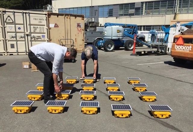
Challenge: National Lab researchers engaged in the DOE’s Next-Generation Ecosystem Experiment (NGEE) Arctic project are working to assess the impact of changes in climate on terrestrial ecosystem dynamics at two locations in Alaska near the Arctic Circle: Council and Barrow. Because the landscapes at these remote sites are generally covered in continuous permafrost and defined by harsh weather conditions, it can be difficult for scientists to sense and quantify the interactions between the subsurface, land, and vegetation using standard instrumentation.
Solution: Engineers and technicians at the GMF helped build and deploy solar-powered and autonomous systems equipped with various ecological, hydrological, and geophysical sensors to enable daily monitoring of vegetation vigor and density, soil-water content, and soil freezing state at these Arctic locations. The systems have been deployed along transects with inline and pole-mounted sensors. GMF also built the Arctic Tram, an autonomous track-mounted platform equipped with multiple remote sensors and cameras for the capture of vegetation reflectance and carbon and energy expenditures. The Arctic Tram is designed to operate autonomously from spring to fall across a 120 m stretch of permafrost landscape. Finally, the GMF team also helped develop vertically resolved temperature probes to capture soil thermal behavior with high-spatiotemporal resolution.
Impact: These sensor arrays and probes make it possible to measure the physical, chemical, and biological behavior of terrestrial ecosystems in one of the most extreme.
Field Sites: Council and Barrow, Alaska
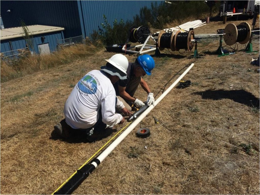
CONTINUOUS ACTIVE SEISMIC SOURCE MODELING (CASSM)
Challenge: Seismic travel-time changes on the scale of microseconds could be missed when using conventional time-lapse surveys to monitor oil and gas reservoirs or aquifers for CO2 sequestration. Without persistent monitoring technologies, difficulties often arise when attempting to relate changes in geophysical characteristics to changes in reservoir saturation and pressure.
Solution: Continuous Active-Source Seismic Monitoring, or CASSM, was developed to solve this challenge by providing real-time, continuous data on reservoir dynamics and to enable detection of reservoir trends that would otherwise go unrecorded by intermittent monitoring. CASSM is a combination of experimental methodology, surveying geometry, and instrumentation developed and built at GMF. For it to be successful, the CASSM approach required a seismic source which could be deployed on the outside of standard production tubing within the tight quarters of an underground observation well. At GMF, researchers designed a hollow tube source from piezoelectric material with an offset center that slides onto the production tubing and can be clamped in place in the borehole for the duration of the seismic monitoring.
Impact: CASSM’s continuous monitoring provides real-time measurement data indicating processes and trends often missed using intermittent measurement methods. The use of crosswell geometry has allowed CASSM to achieve unprecedented precision in seismic monitoring. Berkeley Lab research scientists continue to explore the usefulness of CASSM in various applications, both in the shallow subsurface and in deeper environments such as enhanced geothermal systems and shale gas deposits.
CASSM received a 2015 R&D Award from R&D Magazine.
Field Sites: Texas, Colorado, California and Brooks, Alberta
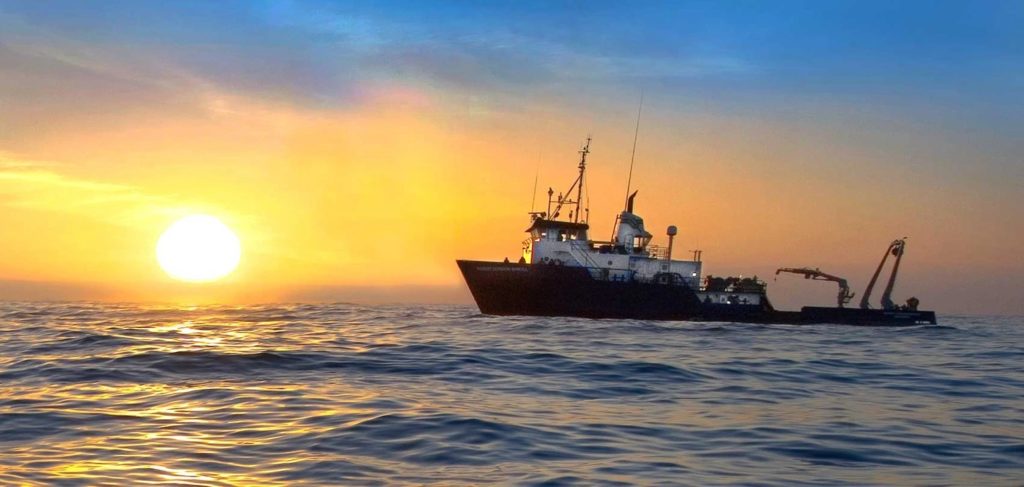
CARBON FLUX EXPLORER
Challenge: Oceans are critical to regulating global atmospheric CO2 levels, but acidification and changes in ocean circulation from even greater atmospheric CO2 threaten the oceans’ ability to act as a biological carbon pump. Predicting future changes in the ocean carbon cycle requires cost-effective, all-weather, and all-season observations of biotic carbon flows across time and space intervals.
Solution: Engineers at GMF helped design and build the Carbon Flux Explorer, a custom optical sedimentation recorder to study the ocean’s biological carbon pump by catching organic matter sinking vertically. OSRs typically hang down from surface buoys, leaving them susceptible to a sideways pull that affects the quantity of particles collected. To create this long-lived robotic float, the team paired the OSR platform with another from the Scripps Institution of Oceanography that measures temperature and salinity. CFEs not only measure overall carbon sedimentation, they can determine exactly what’s in each sample: such as how much of the carbon is locked up in calcium carbonate, which is heavy enough to act as ballast to carry carbon into the deep.
Impact: Since the early 2000s a dozen Carbon Explorers have gathered detailed information on the carbon cycle in the Atlantic, Pacific, and Southern Oceans – information that would be unaffordable and in some cases impossible to obtain from shipboard. Working 24/7 during voyages lasting up to a year or more, CFEs have compiled an average of 350 kilometers (217miles) of up-and-down ocean profiling per float, and they continue to rack up impressive results.
The Carbon Flux Explorer is a 2006 Winner of an R&D 100 award from R&D Magazine.
Field Sites: Atlantic, Pacific, and Southern Oceans
DISTRIBUTED ACOUSTIC SENSING WITH DARK FIBER
Challenge: Traditional seismometers used to observe ground motion and other subsurface processes are sparsely located in clusters across the continents. Researchers wanted to investigate the use of Distributed Acoustic Sensing (DAS) techniques to transform the unused, ubiquitous underground fiber-optic cables known as “dark fiber” into a denser, distributed sensor network capable of remotely detecting earthquakes, the presence of groundwater, changes in permafrost conditions, and a variety of other subsurface changes.
Solution: Distributed Acoustic Sensing (DAS) technology allows unused telecommunication fiber optic cables to be transformed into sensor arrays enabling the measurement of seismic waves over tens of kilometers of linear fiber transects. At the GMF, researchers successfully combined dark fiber with novel DAS data processing techniques to obtain measurements comparable to what conventional seismometers can achieve–but across a much larger geographic area at far less cost. The GMF team helped design and fabricate DAS arrays of varying configurations and tested them for repeatability and quality control.
Impact: The new sensor arrays were used to record a catalog of local, regional, and distant earthquakes. The new instrumentation design enabled the researchers to demonstrate how different processing techniques could be used to leverage DAS’ multiple channels for identifying the source of an earthquake using existing underground dark fiber.
Field Sites: Northern and Southern California
SIMFIP AND ENHANCED GEOTHERMAL SYSTEMS
Challenge: Geothermal energy requires hot rock, fluids, and permeability. In Enhanced Geothermal Systems (EGS), heat acquired from water circulating in rock fractures deep in the subsurface is extracted and converted to electricity. Researchers engaged in the Department of Energy’s EGS Collab Project carefully stimulate, monitor, and characterize geothermal fluid flow paths through subsurface rock nearly a mile underground at the deepest underground laboratory in the country: the Sanford Underground Research Laboratory (SURF) in South Dakota.
Conventionally, separate instruments are used at different points in the process of creating fractures and then monitoring their response to stimulation. Pertinent data is often lost in this time-consuming measurement process, which Berkeley Lab researchers sought to improve with custom-designed subsurface instrumentation for EGS research.
Solution: With the introduction of the unique Step-Rate Injection Method for Fracture In-Situ Properties (SIMFIP) tool, a small device developed at GMF that sits inside a well-bore deep underground, scientists can now both create a fracture and measure its aperture in real-time using the same instrument. Researchers worked alongside engineers at GMF from the earliest stages of SIMFIP’s design process all the way to SIMFIP’s successful deployment at SURF.
Impact: By allowing researchers to directly measure an aperture’s opening in real time, SIMFIP eliminates the need to invert test data after processing, a step that often involves complex modeling concepts. The data acquired using SIMFIP tells scientists investigating the flow of fluids through subsurface rock how a rock fracture is responding to incremental changes in pressure, temperature, stress, or strain, allowing them to improve EGS technologies.
Field Sites: Sanford Underground Research Laboratory (SURF), South Dakota
UAS AERIAL IMAGING
Challenge: Scientists studying remote ecosystems–particularly in challenging locales like the Arctic–have long relied on limited methods to help them understand how elements within these ecosystems interact with each other across space and time. Berkeley Lab researchers needed a better approach to sense and quantify interactions between the subsurface, land, and vegetation in complex ecosystems that are subject to extreme perturbations over short periods of time – such as the Arctic which includes annual freeze-thaw cycles.
Solution: A research team working at the GMF developed an unmanned aerial system that connects drone- and land-based imagery, autonomous geophysics, and telemetry. The monitoring approach is expected to be useful for addressing a variety of questions at different sites. The methods have so far been tested at the NGEE-Arctic project site in Barrow, Alaska, to evaluate seasonal interactions between soil water content, vegetation growth, and permafrost, and at the Watershed Function Scientific Focus Area (SFA) site in Crested Butte, Colorado to explore how mountainous watersheds respond to hydrological perturbations, such as droughts, floods, and early snowmelt.
Impact: UAS Aerial Imaging has enabled rapid sampling over time at high resolution across a large area being studied by NGEE-Arctic researchers. The technology makes it possible for scientists to visualize how different compartments of an ecosystem interact and respond to environmental changes.
Field Sites: Alaska and Colorado
MICROSEISMICITY SENSING
Challenge: Scientists exploring the impact of microseismicity on CO2 sequestration quantify seismic energy using geophones or other sensors inserted into deep boreholes in the subsurface. These traditional sensors are limited in their ability to detect the high frequencies associated with low-magnitude seismic events and do not allow for the use of data stacking, a long-standing technique used to improve signal-to-noise ratios in active-seismic recordings.
Solution: Recording seismic activity on linear Distributed Acoustic Sensing (DAS) fiber with high-density channel spacing allows for stacking of nearby channels to reduce common-mode noise and boost seismic signals. GMF engineers worked alongside EESA researchers to design a new microseismicity sensor array of discrete fiber-optic accelerometers, standard geophones, and a loop of linear DAS fiber deployed in a 1,020-foot borehole on Vancouver Island in British Columbia. Their goal is to evaluate whether the new design of fiber-optic accelerometers are better able to monitor weak signals from microseismic events than traditional sensors in a cemented well – and therefore more likely to detect and locate many more low-magnitude seismic events.
Impact: The Cascadia borehole site, in collaboration with Ocean Networks Canada, is part of an ongoing seismic experiment in the Cascadia Subduction Zone to monitor very weak signals from deep microseismic events likely not being detected via current surface-based seismic monitoring networks. This instrumentation developed at GMF is part of a long-term experiment that will potentially result in higher-resolution subsurface imaging capabilities and significantly improved models for forecasting seismicity.
Field Sites: Vancouver Island, BC
TOMOGRAPHIC ELECTRICAL RHIZOSPHERE IMAGING (TERI)
Challenge: Even with advancements in precision agriculture, there remains a pressing need for nondestructive ways to ”see” into the soil for assessing crop health. The common approach to studying root properties involves excavating roots for analysis in the lab, which does not allow for studies of the same root systems over time.
Solution: By sending a small electrical current into the plant stem, which then travels throughout the root system, Tomographic Electrical Rhizosphere Imaging (TERI) will non-invasively sense the electrical response of both roots and soil and provide information on root mass, surface area, depth, and distribution in the soil, together with data on soil texture and moisture content and how these variables change over time. GMF designed and fabricated a plant growth chamber that provides a view of the living root architecture while measuring plant root response to stimulation by electric pulses.
Impact: The goal for TERI is to develop next-generation root phenotyping technology integrated with ecosystem modeling to accelerate the breeding of root-focused cultivars with certain traits; for example, better climate resiliency and better tolerance for low water and low fertilizer conditions. Ultimately, this tool could help increase yields while increasing carbon input to the soil.
Field Sites: Ardmore, Oklahoma
PORTABLE SEISMIC RECORDERS
Challenge: Geothermal energy, a clean, renewable source of energy produced by the heat of the earth, has the potential to power 100 million American homes – were it not so expensive. Geothermal wells, some deeper than two miles, bring steam to the surface that is converted to electricity. While geothermal technology has been around for some time, one of the main barriers to wider adoption is the high up-front investment. A large geothermal operator might drill three wells a year at a cost of approximately $5-7 million dollars per well. As geothermal reservoirs can be highly compartmentalized into regions of varying productivity, a significant return on investment can be realized by the operator if these wells can be sited in areas with high steam production.
Solution: A network of new portable seismic recorders was tested and evaluated at GMF as part of an effort to help identify more cost-effective means of harnessing geothermal energy. GMF staff worked alongside researchers to deploy 93 of these sensors across a 5 square kilometer area at The Geysers–the world’s largest geothermal field, located north of San Francisco in Sonoma and Lake Counties–to demonstrate the instruments ability to provide high-resolution data for tomographic imaging of an active geothermal field.
Impact: The recorders are intended to provide high-resolution data to allow researchers to image where steam and fluids are going using geophysics. The researchers will improve the spatial resolution of the imaging using a dense array and demonstrate that this can be done cost-effectively in an operating geothermal field.
Field Sites: The Geysers, north of San Francisco